 Add to Chrome
 Add to Firefox
 Add to Edge
Gabriel Cadamuro
A Higher Purpose: Measuring Electricity Access Using High-Resolution Daytime Satellite Imagery
Oct 08, 2022
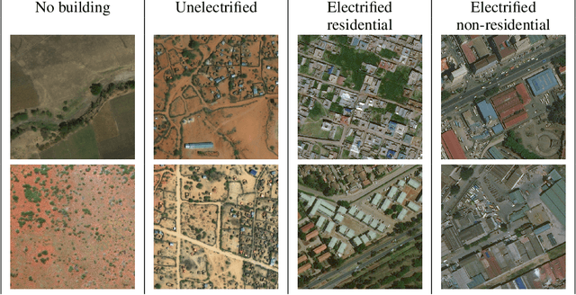


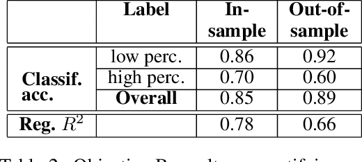
Governments and international organizations the world over are investing towards the goal of achieving universal energy access for improving socio-economic development. However, in developing settings, monitoring electrification efforts is typically inaccurate, infrequent, and expensive. In this work, we develop and present techniques for high-resolution monitoring of electrification progress at scale. Specifically, our 3 unique contributions are: (i) identifying areas with(out) electricity access, (ii) quantifying the extent of electrification in electrified areas (percentage/number of electrified structures), and (iii) differentiating between customer types in electrified regions (estimating the percentage/number of residential/non-residential electrified structures). We combine high-resolution 50 cm daytime satellite images with Convolutional Neural Networks (CNNs) to train a series of classification and regression models. We evaluate our models using unique ground truth datasets on building locations, building types (residential/non-residential), and building electrification status. Our classification models show a 92% accuracy in identifying electrified regions, 85% accuracy in estimating percent of (low/high) electrified buildings within the region, and 69% accuracy in differentiating between (low/high) percentage of electrified residential buildings. Our regressions show $R^2$ scores of 78% and 80% in estimating the number of electrified buildings and number of residential electrified building in images respectively. We also demonstrate the generalizability of our models in never-before-seen regions to assess their potential for consistent and high-resolution measurements of electrification in emerging economies, and conclude by highlighting opportunities for improvement.
Assigning a Grade: Accurate Measurement of Road Quality Using Satellite Imagery
Dec 06, 2018
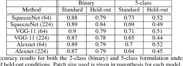
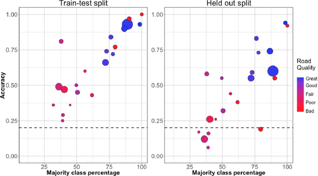
Roads are critically important infrastructure to societal and economic development, with huge investments made by governments every year. However, methods for monitoring those investments tend to be time-consuming, laborious, and expensive, placing them out of reach for many developing regions. In this work, we develop a model for monitoring the quality of road infrastructure using satellite imagery. For this task, we harness two trends: the increasing availability of high-resolution, often-updated satellite imagery, and the enormous improvement in speed and accuracy of convolutional neural network-based methods for performing computer vision tasks. We employ a unique dataset of road quality information on 7000km of roads in Kenya combined with 50cm resolution satellite imagery. We create models for a binary classification task as well as a comprehensive 5-category classification task, with accuracy scores of 88 and 73 percent respectively. We also provide evidence of the robustness of our methods with challenging held-out scenarios, though we note some improvement is still required for confident analysis of a never before seen road. We believe these results are well-positioned to have substantial impact on a broad set of transport applications.