 Add to Chrome
 Add to Firefox
 Add to Edge
Sajad Saeedi
M^3RS: Multi-robot, Multi-objective, and Multi-mode Routing and Scheduling
Mar 24, 2024
In this paper, we present a novel problem coined multi-robot, multi-objective, and multi-mode routing and scheduling (M^3RS). The formulation for M^3RS is introduced for time-bound multi-robot, multi-objective routing and scheduling missions where each task has multiple execution modes. Different execution modes have distinct resource consumption, associated execution time, and quality. M^3RS assigns the optimal sequence of tasks and the execution modes to each agent. The routes and associated modes depend on user preferences for different objective criteria. The need for M^3RS comes from multi-robot applications in which a trade-off between multiple criteria arises from different task execution modes. We use M^3RS for the application of multi-robot disinfection in public locations. The objectives considered for disinfection application are disinfection quality and number of tasks completed. A mixed-integer linear programming model is proposed for M^3RS. Then, a time-efficient column generation scheme is presented to tackle the issue of computation times for larger problem instances. The advantage of using multiple modes over fixed execution mode is demonstrated using experiments on synthetic data. The results suggest that M^3RS provides flexibility to the user in terms of available solutions and performs well in joint performance metrics. The application of the proposed problem is shown for a team of disinfection robots.} The videos for the experiments are available on the project website: https://sites.google.com/view/g-robot/m3rs/ .
Identifying Optimal Launch Sites of High-Altitude Latex-Balloons using Bayesian Optimisation for the Task of Station-Keeping
Mar 16, 2024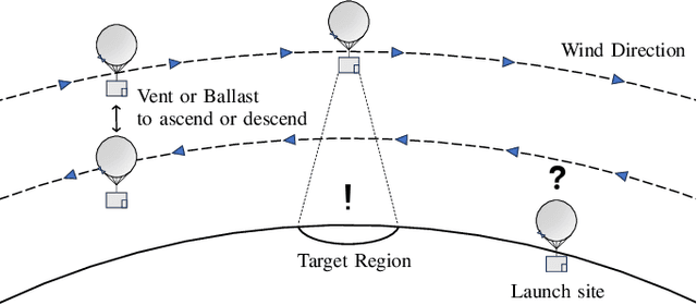
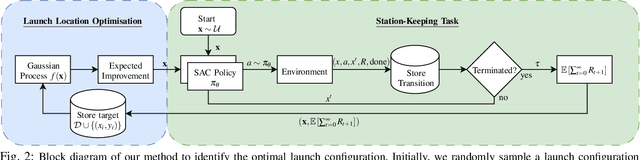
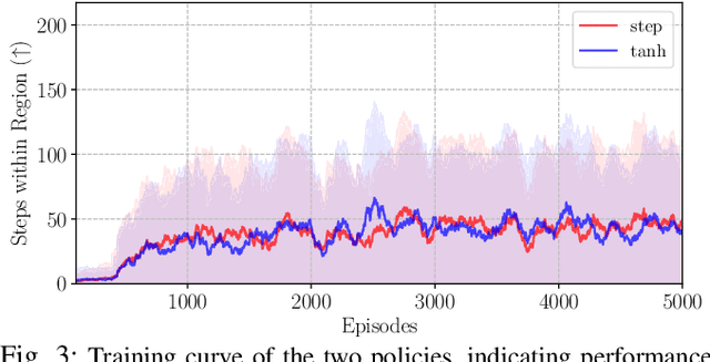
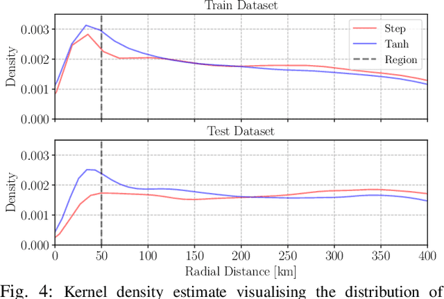
Station-keeping tasks for high-altitude balloons show promise in areas such as ecological surveys, atmospheric analysis, and communication relays. However, identifying the optimal time and position to launch a latex high-altitude balloon is still a challenging and multifaceted problem. For example, tasks such as forest fire tracking place geometric constraints on the launch location of the balloon. Furthermore, identifying the most optimal location also heavily depends on atmospheric conditions. We first illustrate how reinforcement learning-based controllers, frequently used for station-keeping tasks, can exploit the environment. This exploitation can degrade performance on unseen weather patterns and affect station-keeping performance when identifying an optimal launch configuration. Valuing all states equally in the region, the agent exploits the region's geometry by flying near the edge, leading to risky behaviours. We propose a modification which compensates for this exploitation and finds this leads to, on average, higher steps within the target region on unseen data. Then, we illustrate how Bayesian Optimisation (BO) can identify the optimal launch location to perform station-keeping tasks, maximising the expected undiscounted return from a given rollout. We show BO can find this launch location in fewer steps compared to other optimisation methods. Results indicate that, surprisingly, the most optimal location to launch from is not commonly within the target region. Please find further information about our project at https://sites.google.com/view/bo-lauch-balloon/.
DPPE: Dense Pose Estimation in a Plenoxels Environment using Gradient Approximation
Mar 16, 2024
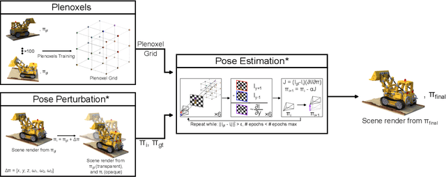
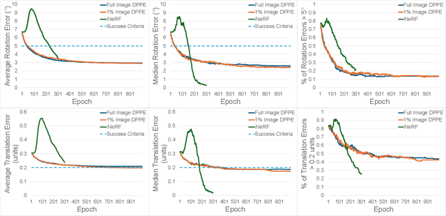
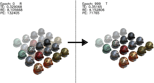
We present DPPE, a dense pose estimation algorithm that functions over a Plenoxels environment. Recent advances in neural radiance field techniques have shown that it is a powerful tool for environment representation. More recent neural rendering algorithms have significantly improved both training duration and rendering speed. Plenoxels introduced a fully-differentiable radiance field technique that uses Plenoptic volume elements contained in voxels for rendering, offering reduced training times and better rendering accuracy, while also eliminating the neural net component. In this work, we introduce a 6-DoF monocular RGB-only pose estimation procedure for Plenoxels, which seeks to recover the ground truth camera pose after a perturbation. We employ a variation on classical template matching techniques, using stochastic gradient descent to optimize the pose by minimizing errors in re-rendering. In particular, we examine an approach that takes advantage of the rapid rendering speed of Plenoxels to numerically approximate part of the pose gradient, using a central differencing technique. We show that such methods are effective in pose estimation. Finally, we perform ablations over key components of the problem space, with a particular focus on image subsampling and Plenoxel grid resolution. Project website: https://sites.google.com/view/dppe
Visual Inertial Odometry using Focal Plane Binary Features (BIT-VIO)
Mar 14, 2024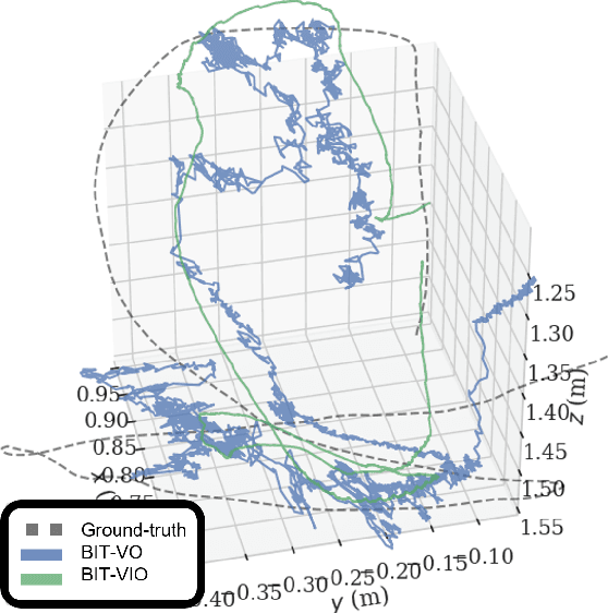
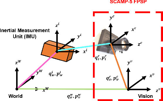
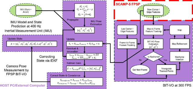
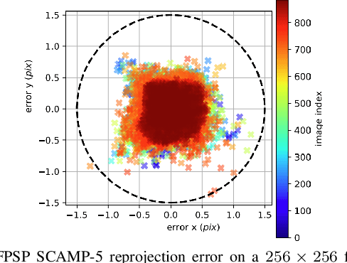
Focal-Plane Sensor-Processor Arrays (FPSP)s are an emerging technology that can execute vision algorithms directly on the image sensor. Unlike conventional cameras, FPSPs perform computation on the image plane -- at individual pixels -- enabling high frame rate image processing while consuming low power, making them ideal for mobile robotics. FPSPs, such as the SCAMP-5, use parallel processing and are based on the Single Instruction Multiple Data (SIMD) paradigm. In this paper, we present BIT-VIO, the first Visual Inertial Odometry (VIO) which utilises SCAMP-5.BIT-VIO is a loosely-coupled iterated Extended Kalman Filter (iEKF) which fuses together the visual odometry running fast at 300 FPS with predictions from 400 Hz IMU measurements to provide accurate and smooth trajectories.
Structure from WiFi (SfW): RSSI-based Geometric Mapping of Indoor Environments
Mar 04, 2024
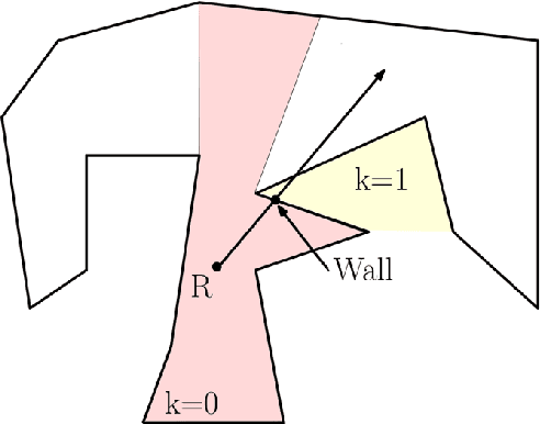
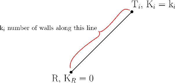
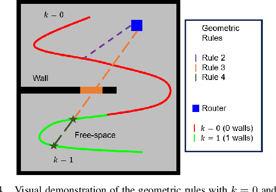
With the rising prominence of WiFi in common spaces, efforts have been made in the robotics community to take advantage of this fact by incorporating WiFi signal measurements in indoor SLAM (Simultaneous Localization and Mapping) systems. SLAM is essential in a wide range of applications, especially in the control of autonomous robots. This paper describes recent work in the development of WiFi-based localization and addresses the challenges currently faced in achieving WiFi-based geometric mapping. Inspired by the field of research into k-visibility, this paper presents the concept of inverse k-visibility and proposes a novel algorithm that allows robots to build a map of the free space of an unknown environment, essential for planning, navigation, and avoiding obstacles. Experiments performed in simulated and real-world environments demonstrate the effectiveness of the proposed algorithm.
DIO: Dataset of 3D Mesh Models of Indoor Objects for Robotics and Computer Vision Applications
Feb 19, 2024The creation of accurate virtual models of real-world objects is imperative to robotic simulations and applications such as computer vision, artificial intelligence, and machine learning. This paper documents the different methods employed for generating a database of mesh models of real-world objects. These methods address the tedious and time-intensive process of manually generating the models using CAD software. Essentially, DSLR/phone cameras were employed to acquire images of target objects. These images were processed using a photogrammetry software known as Meshroom to generate a dense surface reconstruction of the scene. The result produced by Meshroom was edited and simplified using MeshLab, a mesh-editing software to produce the final model. Based on the obtained models, this process was effective in modelling the geometry and texture of real-world objects with high fidelity. An active 3D scanner was also utilized to accelerate the process for large objects. All generated models and captured images are made available on the website of the project.
Sensor Integration and Performance Optimizations for Mineral Exploration using Large-scale Hybrid Multirotor UAVs
Feb 19, 2024In this paper, the focus is on improving the efficiency and precision of mineral data collection using UAVs by addressing key challenges associated with sensor integration. These challenges include mitigating electromagnetic interference, reducing vibration noise, and ensuring consistent sensor performance during flight. The paper demonstrates how innovative approaches to these issues can significantly transform UAV-assisted mineral data collection. Through meticulous design, testing, and evaluation, the study presents experimental evidence of the efficacy of these methods in collecting mineral data via UAVs. The advancements achieved in this research enable the UAV platform to remain airborne up to 6$\times$ longer than standard battery-powered multirotors, while still gathering high-quality mineral data. This leads to increased operational efficiency and reduced costs in UAV-based mineral data-gathering processes
Suspended Magnetometer Survey for Mineral Data Acquisition with Vertical Take-off and Landing Fixed-wing Aircraft
Feb 19, 2024Multirotor Unmanned Aerial Vehicles (UAV)s have recently become an important instrument for collecting mineral data, enabling more effective and accurate geological investigations. This paper explores the difficulties in mounting high-sensitivity sensors on a UAV platform, including electromagnetic interference, payload dynamics, and maintaining stable sensor performance while in flight. It is highlighted how the specific solutions provided to deal with these problems have the potential to alter the collection of mineral data assisted by UAVs. The work also shows experimental findings that demonstrate the creative potential of these solutions in UAV-based mineral data collecting, leading to improvements in effective mineral exploration through careful design, testing, and assessment of these systems. These innovations resulted in a platform that is quickly deployable in remote areas and able to operate more efficiently compared to traditional multirotor UAVs while still producing equal or higher quality mineral data. This allows for much higher efficiency and lower operating costs for high-production UAV-based mineral data acquisition.
Di-NeRF: Distributed NeRF for Collaborative Learning with Unknown Relative Poses
Feb 02, 2024Collaborative mapping of unknown environments can be done faster and more robustly than a single robot. However, a collaborative approach requires a distributed paradigm to be scalable and deal with communication issues. This work presents a fully distributed algorithm enabling a group of robots to collectively optimize the parameters of a Neural Radiance Field (NeRF). The algorithm involves the communication of each robot's trained NeRF parameters over a mesh network, where each robot trains its NeRF and has access to its own visual data only. Additionally, the relative poses of all robots are jointly optimized alongside the model parameters, enabling mapping with unknown relative camera poses. We show that multi-robot systems can benefit from differentiable and robust 3D reconstruction optimized from multiple NeRFs. Experiments on real-world and synthetic data demonstrate the efficiency of the proposed algorithm. See the website of the project for videos of the experiments and supplementary material(https://sites.google.com/view/di-nerf/home).
MR.CAP: Multi-Robot Joint Control and Planning for Object Transport
Jan 22, 2024With the recent influx in demand for multi-robot systems throughout industry and academia, there is an increasing need for faster, robust, and generalizable path planning algorithms. Similarly, given the inherent connection between control algorithms and multi-robot path planners, there is in turn an increased demand for fast, efficient, and robust controllers. We propose a scalable joint path planning and control algorithm for multi-robot systems with constrained behaviours based on factor graph optimization. We demonstrate our algorithm on a series of hardware and simulated experiments. Our algorithm is consistently able to recover from disturbances and avoid obstacles while outperforming state-of-the-art methods in optimization time, path deviation, and inter-robot errors. See the code and supplementary video for experiments.