 Add to Chrome
 Add to Firefox
 Add to Edge
Stefan Auer
Towards Large-scale Building Attribute Mapping using Crowdsourced Images: Scene Text Recognition on Flickr and Problems to be Solved
Sep 14, 2023
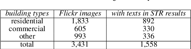
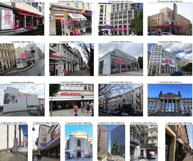
Crowdsourced platforms provide huge amounts of street-view images that contain valuable building information. This work addresses the challenges in applying Scene Text Recognition (STR) in crowdsourced street-view images for building attribute mapping. We use Flickr images, particularly examining texts on building facades. A Berlin Flickr dataset is created, and pre-trained STR models are used for text detection and recognition. Manual checking on a subset of STR-recognized images demonstrates high accuracy. We examined the correlation between STR results and building functions, and analysed instances where texts were recognized on residential buildings but not on commercial ones. Further investigation revealed significant challenges associated with this task, including small text regions in street-view images, the absence of ground truth labels, and mismatches in buildings in Flickr images and building footprints in OpenStreetMap (OSM). To develop city-wide mapping beyond urban hotspot locations, we suggest differentiating the scenarios where STR proves effective while developing appropriate algorithms or bringing in additional data for handling other cases. Furthermore, interdisciplinary collaboration should be undertaken to understand the motivation behind building photography and labeling. The STR-on-Flickr results are publicly available at https://github.com/ya0-sun/STR-Berlin.
Drones4Good: Supporting Disaster Relief Through Remote Sensing and AI
Aug 09, 2023


In order to respond effectively in the aftermath of a disaster, emergency services and relief organizations rely on timely and accurate information about the affected areas. Remote sensing has the potential to significantly reduce the time and effort required to collect such information by enabling a rapid survey of large areas. To achieve this, the main challenge is the automatic extraction of relevant information from remotely sensed data. In this work, we show how the combination of drone-based data with deep learning methods enables automated and large-scale situation assessment. In addition, we demonstrate the integration of onboard image processing techniques for the deployment of autonomous drone-based aid delivery. The results show the feasibility of a rapid and large-scale image analysis in the field, and that onboard image processing can increase the safety of drone-based aid deliveries.
Generative Adversarial Networks for Synthesizing InSAR Patches
Aug 03, 2020


Generative Adversarial Networks (GANs) have been employed with certain success for image translation tasks between optical and real-valued SAR intensity imagery. Applications include aiding interpretability of SAR scenes with their optical counterparts by artificial patch generation and automatic SAR-optical scene matching. The synthesis of artificial complex-valued InSAR image stacks asks for, besides good perceptual quality, more stringent quality metrics like phase noise and phase coherence. This paper provides a signal processing model of generative CNN structures, describes effects influencing those quality metrics and presents a mapping scheme of complex-valued data to given CNN structures based on popular Deep Learning frameworks.