 Add to Chrome
 Add to Firefox
 Add to Edge
Joao P. Leitao
Data-driven Flood Emulation: Speeding up Urban Flood Predictions by Deep Convolutional Neural Networks
May 13, 2020
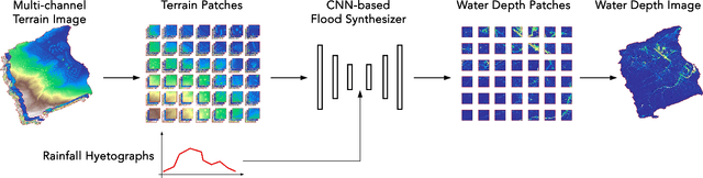
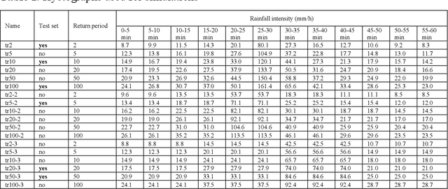
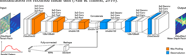
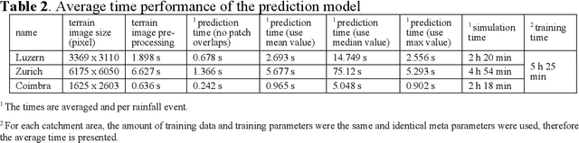
Computational complexity has been the bottleneck of applying physically-based simulations on large urban areas with high spatial resolution for efficient and systematic flooding analyses and risk assessments. To address this issue of long computational time, this paper proposes that the prediction of maximum water depth rasters can be considered as an image-to-image translation problem where the results are generated from input elevation rasters using the information learned from data rather than by conducting simulations, which can significantly accelerate the prediction process. The proposed approach was implemented by a deep convolutional neural network trained on flood simulation data of 18 designed hyetographs on three selected catchments. Multiple tests with both designed and real rainfall events were performed and the results show that the flood predictions by neural network uses only 0.5 % of time comparing with physically-based approaches, with promising accuracy and ability of generalizations. The proposed neural network can also potentially be applied to different but relevant problems including flood predictions for urban layout planning.
Modeling overland flow from local inflows in almost no-time, using Self Organizing Maps
Sep 23, 2018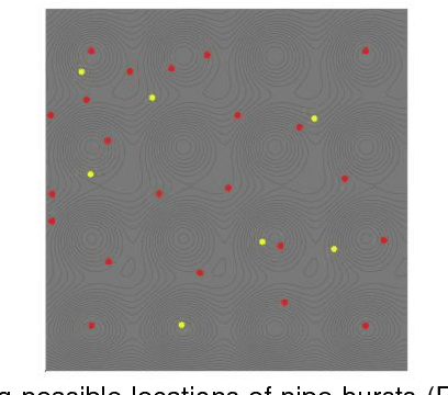
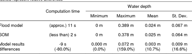
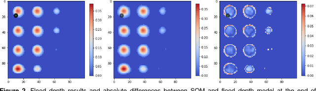
Physically-based overland flow models are computationally demanding, hindering their use for real-time applications. Therefore, the development of fast (and reasonably accurate) overland flow models is needed if they are to be used to support flood mitigation decision making. In this study, we investigate the potential of Self-Organizing Maps to rapidly generate water depth and flood extent results. To conduct the study, we developed a flood-simulation specific SOM, using cellular automata flood model results and a synthetic DEM and inflow hydrograph. The preliminary results showed that water depth and flood extent results produced by the SOM are reasonably accurate and obtained in a very short period of time. Based on this, it seems that SOMs have the potential to provide critical flood information to support real-time flood mitigation decisions. The findings presented would however require further investigations to obtain general conclusions; these further investigations may include the consideration of real terrain representations, real water supply networks and realistic inflows from pipe bursts.