 Add to Chrome
 Add to Firefox
 Add to Edge
Vahid Moosavi
Data-driven Flood Emulation: Speeding up Urban Flood Predictions by Deep Convolutional Neural Networks
May 13, 2020
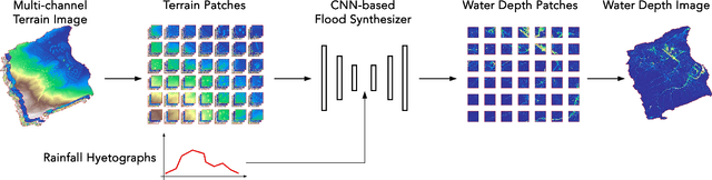
Computational complexity has been the bottleneck of applying physically-based simulations on large urban areas with high spatial resolution for efficient and systematic flooding analyses and risk assessments. To address this issue of long computational time, this paper proposes that the prediction of maximum water depth rasters can be considered as an image-to-image translation problem where the results are generated from input elevation rasters using the information learned from data rather than by conducting simulations, which can significantly accelerate the prediction process. The proposed approach was implemented by a deep convolutional neural network trained on flood simulation data of 18 designed hyetographs on three selected catchments. Multiple tests with both designed and real rainfall events were performed and the results show that the flood predictions by neural network uses only 0.5 % of time comparing with physically-based approaches, with promising accuracy and ability of generalizations. The proposed neural network can also potentially be applied to different but relevant problems including flood predictions for urban layout planning.
Data-Driven Design: Exploring new Structural Forms using Machine Learning and Graphic Statics
Sep 23, 2018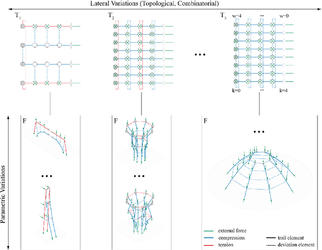
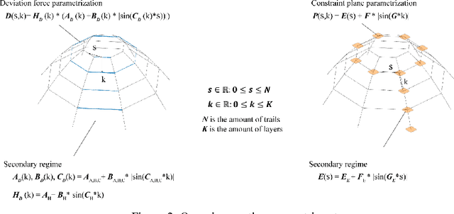
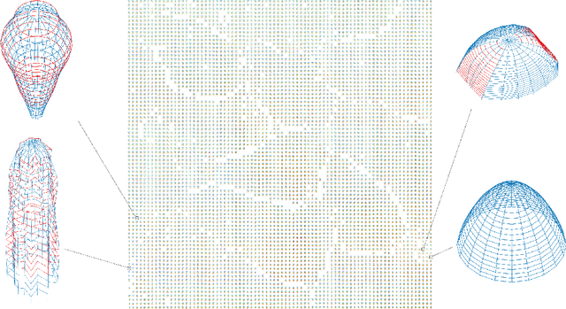
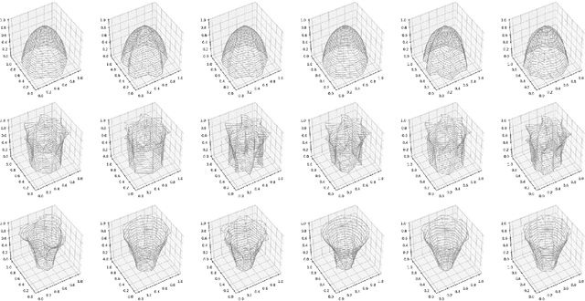
The aim of this research is to introduce a novel structural design process that allows architects and engineers to extend their typical design space horizon and thereby promoting the idea of creativity in structural design. The theoretical base of this work builds on the combination of structural form-finding and state-of-the-art machine learning algorithms. In the first step of the process, Combinatorial Equilibrium Modelling (CEM) is used to generate a large variety of spatial networks in equilibrium for given input parameters. In the second step, these networks are clustered and represented in a form-map through the implementation of a Self Organizing Map (SOM) algorithm. In the third step, the solution space is interpreted with the help of a Uniform Manifold Approximation and Projection algorithm (UMAP). This allows gaining important insights in the structure of the solution space. A specific case study is used to illustrate how the infinite equilibrium states of a given topology can be defined and represented by clusters. Furthermore, three classes, related to the non-linear interaction between the input parameters and the form space, are verified and a statement about the entire manifold of the solution space of the case study is made. To conclude, this work presents an innovative approach on how the manifold of a solution space can be grasped with a minimum amount of data and how to operate within the manifold in order to increase the diversity of solutions.
Modeling overland flow from local inflows in almost no-time, using Self Organizing Maps
Sep 23, 2018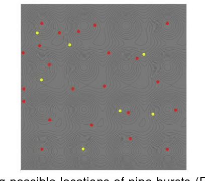
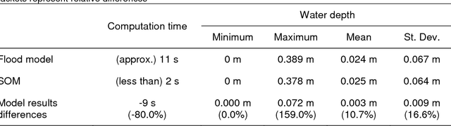
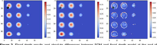
Physically-based overland flow models are computationally demanding, hindering their use for real-time applications. Therefore, the development of fast (and reasonably accurate) overland flow models is needed if they are to be used to support flood mitigation decision making. In this study, we investigate the potential of Self-Organizing Maps to rapidly generate water depth and flood extent results. To conduct the study, we developed a flood-simulation specific SOM, using cellular automata flood model results and a synthetic DEM and inflow hydrograph. The preliminary results showed that water depth and flood extent results produced by the SOM are reasonably accurate and obtained in a very short period of time. Based on this, it seems that SOMs have the potential to provide critical flood information to support real-time flood mitigation decisions. The findings presented would however require further investigations to obtain general conclusions; these further investigations may include the consideration of real terrain representations, real water supply networks and realistic inflows from pipe bursts.
Urban morphology meets deep learning: Exploring urban forms in one million cities, town and villages across the planet
Sep 12, 2017
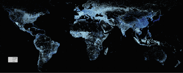
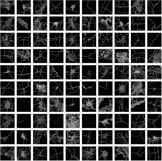
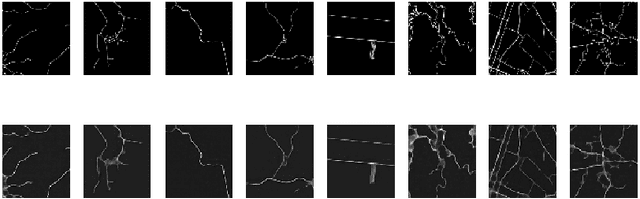
Study of urban form is an important area of research in urban planning/design that contributes to our understanding of how cities function and evolve. However, classical approaches are based on very limited observations and inconsistent methods. As an alternative, availability of massive urban data collections such as Open Street Map from the one hand and the recent advancements in machine learning methods such as deep learning techniques on the other have opened up new possibilities to automatically investigate urban forms at the global scale. In this work for the first time, by collecting a large data set of street networks in more than one million cities, towns and villages all over the world, we trained a deep convolutional auto-encoder, that automatically learns the hierarchical structures of urban forms and represents them via dense and comparable vectors. We showed how the learned urban vectors could be used for different investigations. Using the learned urban vectors, one is able to easily find and compare similar urban forms all over the world, considering their overall spatial structure and other factors such as orientation, graphical structure, and density and partial deformations. Further cluster analysis reveals the distribution of the main patterns of urban forms all over the planet.
Computational Machines in a Coexistence with Concrete Universals and Data Streams
Sep 10, 2017
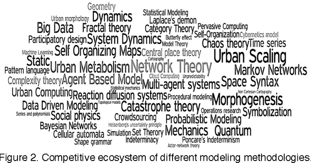
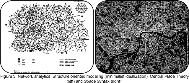
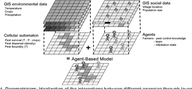
We discuss that how the majority of traditional modeling approaches are following the idealism point of view in scientific modeling, which follow the set theoretical notions of models based on abstract universals. We show that while successful in many classical modeling domains, there are fundamental limits to the application of set theoretical models in dealing with complex systems with many potential aspects or properties depending on the perspectives. As an alternative to abstract universals, we propose a conceptual modeling framework based on concrete universals that can be interpreted as a category theoretical approach to modeling. We call this modeling framework pre-specific modeling. We further, discuss how a certain group of mathematical and computational methods, along with ever-growing data streams are able to operationalize the concept of pre-specific modeling.
Computing With Contextual Numbers
Aug 06, 2014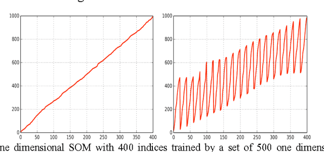
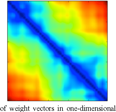
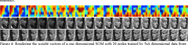
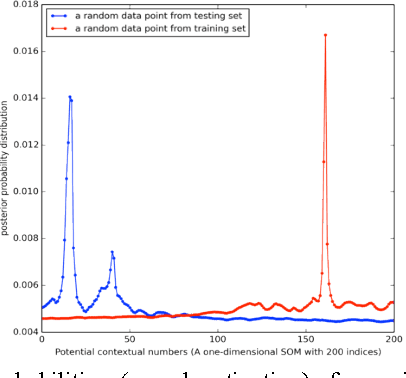
Self Organizing Map (SOM) has been applied into several classical modeling tasks including clustering, classification, function approximation and visualization of high dimensional spaces. The final products of a trained SOM are a set of ordered (low dimensional) indices and their associated high dimensional weight vectors. While in the above-mentioned applications, the final high dimensional weight vectors play the primary role in the computational steps, from a certain perspective, one can interpret SOM as a nonparametric encoder, in which the final low dimensional indices of the trained SOM are pointer to the high dimensional space. We showed how using a one-dimensional SOM, which is not common in usual applications of SOM, one can develop a nonparametric mapping from a high dimensional space to a continuous one-dimensional numerical field. These numerical values, called contextual numbers, are ordered in a way that in a given context, similar numbers refer to similar high dimensional states. Further, as these numbers can be treated similarly to usual continuous numbers, they can be replaced with their corresponding high dimensional states within any data driven modeling problem. As a potential application, we showed how using contextual numbers could be used for the problem of high dimensional spatiotemporal dynamics.