 Add to Chrome
 Add to Firefox
 Add to Edge
Sergio Casas
QuAD: Query-based Interpretable Neural Motion Planning for Autonomous Driving
Apr 01, 2024
A self-driving vehicle must understand its environment to determine the appropriate action. Traditional autonomy systems rely on object detection to find the agents in the scene. However, object detection assumes a discrete set of objects and loses information about uncertainty, so any errors compound when predicting the future behavior of those agents. Alternatively, dense occupancy grid maps have been utilized to understand free-space. However, predicting a grid for the entire scene is wasteful since only certain spatio-temporal regions are reachable and relevant to the self-driving vehicle. We present a unified, interpretable, and efficient autonomy framework that moves away from cascading modules that first perceive, then predict, and finally plan. Instead, we shift the paradigm to have the planner query occupancy at relevant spatio-temporal points, restricting the computation to those regions of interest. Exploiting this representation, we evaluate candidate trajectories around key factors such as collision avoidance, comfort, and progress for safety and interpretability. Our approach achieves better highway driving quality than the state-of-the-art in high-fidelity closed-loop simulations.
4D-Former: Multimodal 4D Panoptic Segmentation
Nov 17, 2023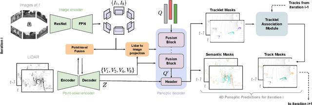
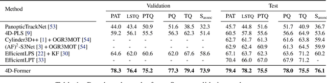
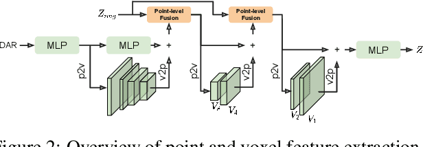
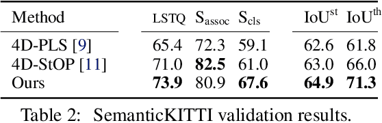
4D panoptic segmentation is a challenging but practically useful task that requires every point in a LiDAR point-cloud sequence to be assigned a semantic class label, and individual objects to be segmented and tracked over time. Existing approaches utilize only LiDAR inputs which convey limited information in regions with point sparsity. This problem can, however, be mitigated by utilizing RGB camera images which offer appearance-based information that can reinforce the geometry-based LiDAR features. Motivated by this, we propose 4D-Former: a novel method for 4D panoptic segmentation which leverages both LiDAR and image modalities, and predicts semantic masks as well as temporally consistent object masks for the input point-cloud sequence. We encode semantic classes and objects using a set of concise queries which absorb feature information from both data modalities. Additionally, we propose a learned mechanism to associate object tracks over time which reasons over both appearance and spatial location. We apply 4D-Former to the nuScenes and SemanticKITTI datasets where it achieves state-of-the-art results.
Towards Unsupervised Object Detection From LiDAR Point Clouds
Nov 03, 2023In this paper, we study the problem of unsupervised object detection from 3D point clouds in self-driving scenes. We present a simple yet effective method that exploits (i) point clustering in near-range areas where the point clouds are dense, (ii) temporal consistency to filter out noisy unsupervised detections, (iii) translation equivariance of CNNs to extend the auto-labels to long range, and (iv) self-supervision for improving on its own. Our approach, OYSTER (Object Discovery via Spatio-Temporal Refinement), does not impose constraints on data collection (such as repeated traversals of the same location), is able to detect objects in a zero-shot manner without supervised finetuning (even in sparse, distant regions), and continues to self-improve given more rounds of iterative self-training. To better measure model performance in self-driving scenarios, we propose a new planning-centric perception metric based on distance-to-collision. We demonstrate that our unsupervised object detector significantly outperforms unsupervised baselines on PandaSet and Argoverse 2 Sensor dataset, showing promise that self-supervision combined with object priors can enable object discovery in the wild. For more information, visit the project website: https://waabi.ai/research/oyster
MemorySeg: Online LiDAR Semantic Segmentation with a Latent Memory
Nov 02, 2023Semantic segmentation of LiDAR point clouds has been widely studied in recent years, with most existing methods focusing on tackling this task using a single scan of the environment. However, leveraging the temporal stream of observations can provide very rich contextual information on regions of the scene with poor visibility (e.g., occlusions) or sparse observations (e.g., at long range), and can help reduce redundant computation frame after frame. In this paper, we tackle the challenge of exploiting the information from the past frames to improve the predictions of the current frame in an online fashion. To address this challenge, we propose a novel framework for semantic segmentation of a temporal sequence of LiDAR point clouds that utilizes a memory network to store, update and retrieve past information. Our framework also includes a regularizer that penalizes prediction variations in the neighborhood of the point cloud. Prior works have attempted to incorporate memory in range view representations for semantic segmentation, but these methods fail to handle occlusions and the range view representation of the scene changes drastically as agents nearby move. Our proposed framework overcomes these limitations by building a sparse 3D latent representation of the surroundings. We evaluate our method on SemanticKITTI, nuScenes, and PandaSet. Our experiments demonstrate the effectiveness of the proposed framework compared to the state-of-the-art.
LabelFormer: Object Trajectory Refinement for Offboard Perception from LiDAR Point Clouds
Nov 02, 2023A major bottleneck to scaling-up training of self-driving perception systems are the human annotations required for supervision. A promising alternative is to leverage "auto-labelling" offboard perception models that are trained to automatically generate annotations from raw LiDAR point clouds at a fraction of the cost. Auto-labels are most commonly generated via a two-stage approach -- first objects are detected and tracked over time, and then each object trajectory is passed to a learned refinement model to improve accuracy. Since existing refinement models are overly complex and lack advanced temporal reasoning capabilities, in this work we propose LabelFormer, a simple, efficient, and effective trajectory-level refinement approach. Our approach first encodes each frame's observations separately, then exploits self-attention to reason about the trajectory with full temporal context, and finally decodes the refined object size and per-frame poses. Evaluation on both urban and highway datasets demonstrates that LabelFormer outperforms existing works by a large margin. Finally, we show that training on a dataset augmented with auto-labels generated by our method leads to improved downstream detection performance compared to existing methods. Please visit the project website for details https://waabi.ai/labelformer
* 20 pages, 8 figures, 7 tables
Learning Unsupervised World Models for Autonomous Driving via Discrete Diffusion
Nov 02, 2023Learning world models can teach an agent how the world works in an unsupervised manner. Even though it can be viewed as a special case of sequence modeling, progress for scaling world models on robotic applications such as autonomous driving has been somewhat less rapid than scaling language models with Generative Pre-trained Transformers (GPT). We identify two reasons as major bottlenecks: dealing with complex and unstructured observation space, and having a scalable generative model. Consequently, we propose a novel world modeling approach that first tokenizes sensor observations with VQVAE, then predicts the future via discrete diffusion. To efficiently decode and denoise tokens in parallel, we recast Masked Generative Image Transformer into the discrete diffusion framework with a few simple changes, resulting in notable improvement. When applied to learning world models on point cloud observations, our model reduces prior SOTA Chamfer distance by more than 65% for 1s prediction, and more than 50% for 3s prediction, across NuScenes, KITTI Odometry, and Argoverse2 datasets. Our results demonstrate that discrete diffusion on tokenized agent experience can unlock the power of GPT-like unsupervised learning for robotic agents.
Implicit Occupancy Flow Fields for Perception and Prediction in Self-Driving
Aug 02, 2023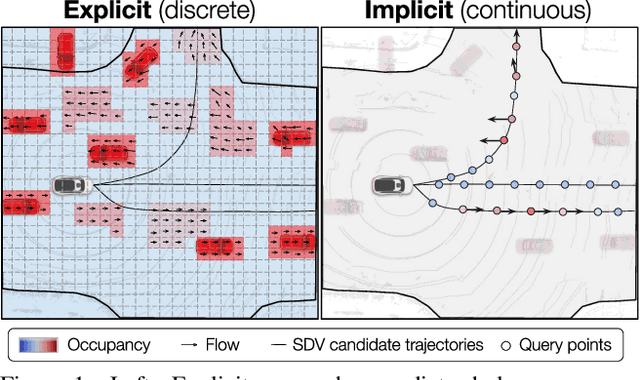
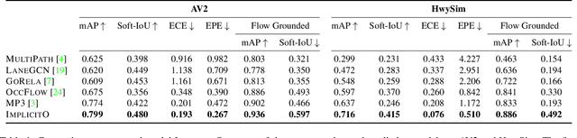
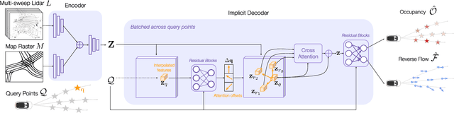
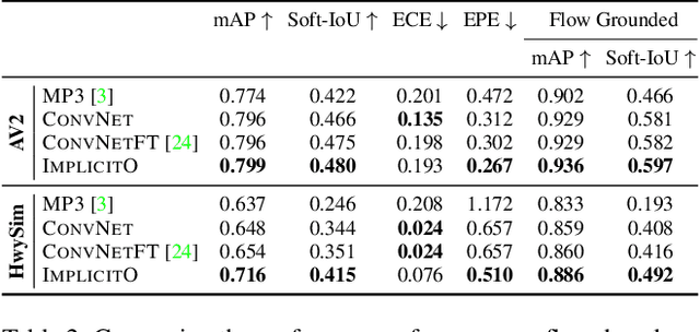
A self-driving vehicle (SDV) must be able to perceive its surroundings and predict the future behavior of other traffic participants. Existing works either perform object detection followed by trajectory forecasting of the detected objects, or predict dense occupancy and flow grids for the whole scene. The former poses a safety concern as the number of detections needs to be kept low for efficiency reasons, sacrificing object recall. The latter is computationally expensive due to the high-dimensionality of the output grid, and suffers from the limited receptive field inherent to fully convolutional networks. Furthermore, both approaches employ many computational resources predicting areas or objects that might never be queried by the motion planner. This motivates our unified approach to perception and future prediction that implicitly represents occupancy and flow over time with a single neural network. Our method avoids unnecessary computation, as it can be directly queried by the motion planner at continuous spatio-temporal locations. Moreover, we design an architecture that overcomes the limited receptive field of previous explicit occupancy prediction methods by adding an efficient yet effective global attention mechanism. Through extensive experiments in both urban and highway settings, we demonstrate that our implicit model outperforms the current state-of-the-art. For more information, visit the project website: https://waabi.ai/research/implicito.
* 19 pages, 13 figures
GoRela: Go Relative for Viewpoint-Invariant Motion Forecasting
Nov 08, 2022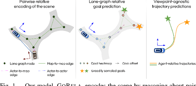
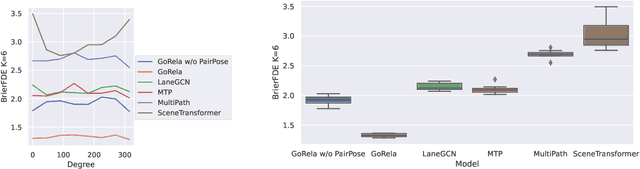
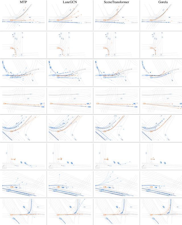
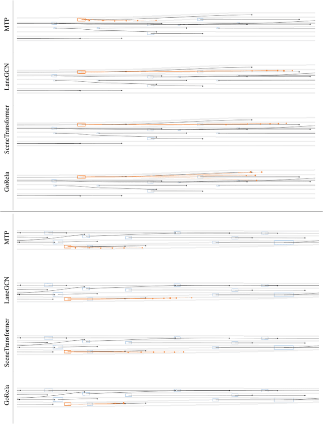
The task of motion forecasting is critical for self-driving vehicles (SDVs) to be able to plan a safe maneuver. Towards this goal, modern approaches reason about the map, the agents' past trajectories and their interactions in order to produce accurate forecasts. The predominant approach has been to encode the map and other agents in the reference frame of each target agent. However, this approach is computationally expensive for multi-agent prediction as inference needs to be run for each agent. To tackle the scaling challenge, the solution thus far has been to encode all agents and the map in a shared coordinate frame (e.g., the SDV frame). However, this is sample inefficient and vulnerable to domain shift (e.g., when the SDV visits uncommon states). In contrast, in this paper, we propose an efficient shared encoding for all agents and the map without sacrificing accuracy or generalization. Towards this goal, we leverage pair-wise relative positional encodings to represent geometric relationships between the agents and the map elements in a heterogeneous spatial graph. This parameterization allows us to be invariant to scene viewpoint, and save online computation by re-using map embeddings computed offline. Our decoder is also viewpoint agnostic, predicting agent goals on the lane graph to enable diverse and context-aware multimodal prediction. We demonstrate the effectiveness of our approach on the urban Argoverse 2 benchmark as well as a novel highway dataset.