 Add to Chrome
 Add to Firefox
 Add to Edge
Sebastian Scherer
General Place Recognition Survey: Towards Real-World Autonomy
May 08, 2024
In the realm of robotics, the quest for achieving real-world autonomy, capable of executing large-scale and long-term operations, has positioned place recognition (PR) as a cornerstone technology. Despite the PR community's remarkable strides over the past two decades, garnering attention from fields like computer vision and robotics, the development of PR methods that sufficiently support real-world robotic systems remains a challenge. This paper aims to bridge this gap by highlighting the crucial role of PR within the framework of Simultaneous Localization and Mapping (SLAM) 2.0. This new phase in robotic navigation calls for scalable, adaptable, and efficient PR solutions by integrating advanced artificial intelligence (AI) technologies. For this goal, we provide a comprehensive review of the current state-of-the-art (SOTA) advancements in PR, alongside the remaining challenges, and underscore its broad applications in robotics. This paper begins with an exploration of PR's formulation and key research challenges. We extensively review literature, focusing on related methods on place representation and solutions to various PR challenges. Applications showcasing PR's potential in robotics, key PR datasets, and open-source libraries are discussed. We also emphasizes our open-source package, aimed at new development and benchmark for general PR. We conclude with a discussion on PR's future directions, accompanied by a summary of the literature covered and access to our open-source library, available to the robotics community at: https://github.com/MetaSLAM/GPRS.
AirShot: Efficient Few-Shot Detection for Autonomous Exploration
Apr 07, 2024Few-shot object detection has drawn increasing attention in the field of robotic exploration, where robots are required to find unseen objects with a few online provided examples. Despite recent efforts have been made to yield online processing capabilities, slow inference speeds of low-powered robots fail to meet the demands of real-time detection-making them impractical for autonomous exploration. Existing methods still face performance and efficiency challenges, mainly due to unreliable features and exhaustive class loops. In this work, we propose a new paradigm AirShot, and discover that, by fully exploiting the valuable correlation map, AirShot can result in a more robust and faster few-shot object detection system, which is more applicable to robotics community. The core module Top Prediction Filter (TPF) can operate on multi-scale correlation maps in both the training and inference stages. During training, TPF supervises the generation of a more representative correlation map, while during inference, it reduces looping iterations by selecting top-ranked classes, thus cutting down on computational costs with better performance. Surprisingly, this dual functionality exhibits general effectiveness and efficiency on various off-the-shelf models. Exhaustive experiments on COCO2017, VOC2014, and SubT datasets demonstrate that TPF can significantly boost the efficacy and efficiency of most off-the-shelf models, achieving up to 36.4% precision improvements along with 56.3% faster inference speed. Code and Data are at: https://github.com/ImNotPrepared/AirShot.
Multi-Robot Planning for Filming Groups of Moving Actors Leveraging Submodularity and Pixel Density
Apr 03, 2024Observing and filming a group of moving actors with a team of aerial robots is a challenging problem that combines elements of multi-robot coordination, coverage, and view planning. A single camera may observe multiple actors at once, and the robot team may observe individual actors from multiple views. As actors move about, groups may split, merge, and reform, and robots filming these actors should be able to adapt smoothly to such changes in actor formations. Rather than adopt an approach based on explicit formations or assignments, we propose an approach based on optimizing views directly. We model actors as moving polyhedra and compute approximate pixel densities for each face and camera view. Then, we propose an objective that exhibits diminishing returns as pixel densities increase from repeated observation. This gives rise to a multi-robot perception planning problem which we solve via a combination of value iteration and greedy submodular maximization. %using a combination of value iteration to optimize views for individual robots and sequential submodular maximization methods to coordinate the team. We evaluate our approach on challenging scenarios modeled after various kinds of social behaviors and featuring different numbers of robots and actors and observe that robot assignments and formations arise implicitly based on the movements of groups of actors. Simulation results demonstrate that our approach consistently outperforms baselines, and in addition to performing well with the planner's approximation of pixel densities our approach also performs comparably for evaluation based on rendered views. Overall, the multi-round variant of the sequential planner we propose meets (within 1%) or exceeds the formation and assignment baselines in all scenarios we consider.
Deep Bayesian Future Fusion for Self-Supervised, High-Resolution, Off-Road Mapping
Mar 18, 2024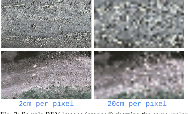
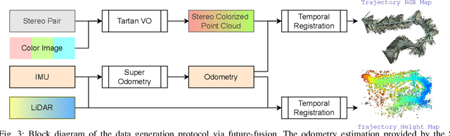
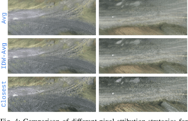
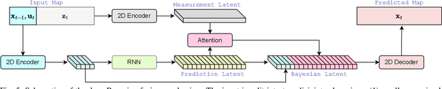
The limited sensing resolution of resource-constrained off-road vehicles poses significant challenges towards reliable off-road autonomy. To overcome this limitation, we propose a general framework based on fusing the future information (i.e. future fusion) for self-supervision. Recent approaches exploit this future information alongside the hand-crafted heuristics to directly supervise the targeted downstream tasks (e.g. traversability estimation). However, in this paper, we opt for a more general line of development - time-efficient completion of the highest resolution (i.e. 2cm per pixel) BEV map in a self-supervised manner via future fusion, which can be used for any downstream tasks for better longer range prediction. To this end, first, we create a high-resolution future-fusion dataset containing pairs of (RGB / height) raw sparse and noisy inputs and map-based dense labels. Next, to accommodate the noise and sparsity of the sensory information, especially in the distal regions, we design an efficient realization of the Bayes filter onto the vanilla convolutional network via the recurrent mechanism. Equipped with the ideas from SOTA generative models, our Bayesian structure effectively predicts high-quality BEV maps in the distal regions. Extensive evaluation on both the quality of completion and downstream task on our future-fusion dataset demonstrates the potential of our approach.
Learning Generalizable Feature Fields for Mobile Manipulation
Mar 12, 2024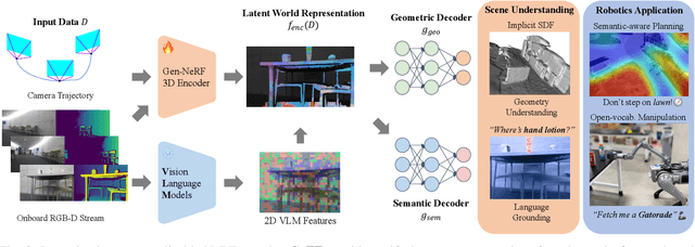
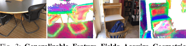
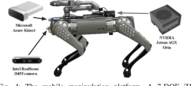
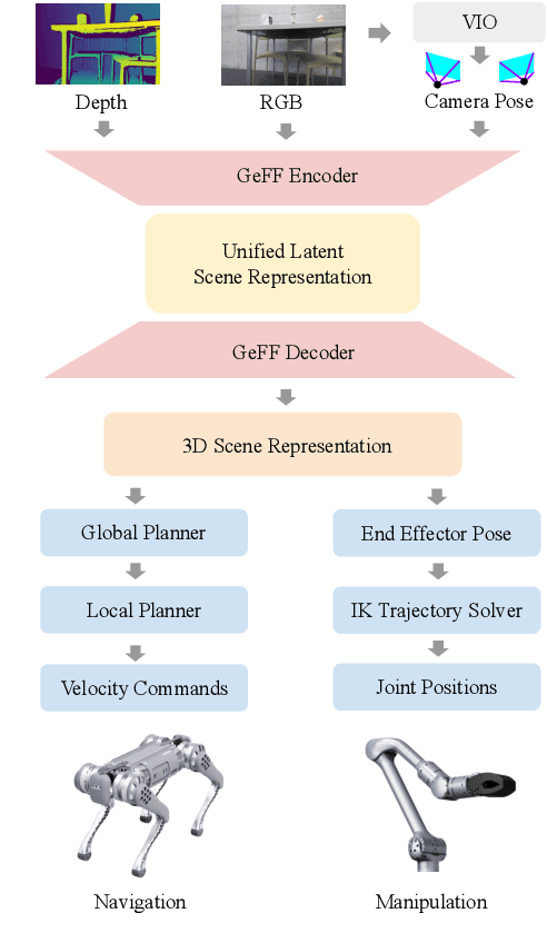
An open problem in mobile manipulation is how to represent objects and scenes in a unified manner, so that robots can use it both for navigating in the environment and manipulating objects. The latter requires capturing intricate geometry while understanding fine-grained semantics, whereas the former involves capturing the complexity inherit to an expansive physical scale. In this work, we present GeFF (Generalizable Feature Fields), a scene-level generalizable neural feature field that acts as a unified representation for both navigation and manipulation that performs in real-time. To do so, we treat generative novel view synthesis as a pre-training task, and then align the resulting rich scene priors with natural language via CLIP feature distillation. We demonstrate the effectiveness of this approach by deploying GeFF on a quadrupedal robot equipped with a manipulator. We evaluate GeFF's ability to generalize to open-set objects as well as running time, when performing open-vocabulary mobile manipulation in dynamic scenes.
TartanAviation: Image, Speech, and ADS-B Trajectory Datasets for Terminal Airspace Operations
Mar 05, 2024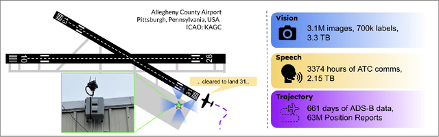


We introduce TartanAviation, an open-source multi-modal dataset focused on terminal-area airspace operations. TartanAviation provides a holistic view of the airport environment by concurrently collecting image, speech, and ADS-B trajectory data using setups installed inside airport boundaries. The datasets were collected at both towered and non-towered airfields across multiple months to capture diversity in aircraft operations, seasons, aircraft types, and weather conditions. In total, TartanAviation provides 3.1M images, 3374 hours of Air Traffic Control speech data, and 661 days of ADS-B trajectory data. The data was filtered, processed, and validated to create a curated dataset. In addition to the dataset, we also open-source the code-base used to collect and pre-process the dataset, further enhancing accessibility and usability. We believe this dataset has many potential use cases and would be particularly vital in allowing AI and machine learning technologies to be integrated into air traffic control systems and advance the adoption of autonomous aircraft in the airspace.
A Unified MPC Strategy for a Tilt-rotor VTOL UAV Towards Seamless Mode Transitioning
Feb 12, 2024Capabilities of long-range flight and vertical take-off and landing (VTOL) are essential for Urban Air Mobility (UAM). Tiltrotor VTOLs have the advantage of balancing control simplicity and system complexity due to their redundant control authority. Prior work on controlling these aircraft either requires separate controllers and switching modes for different vehicle configurations or performs the control allocation on separate actuator sets, which cannot fully use the potential of the redundancy of tiltrotor. This paper introduces a unified MPC-based control strategy for a customized tiltrotor VTOL Unmanned Aerial Vehicle (UAV), which does not require mode-switching and can perform the control allocation in a consistent way. The incorporation of four independently controllable rotors in VTOL design offers an extra level of redundancy, allowing the VTOL to accommodate actuator failures. The result shows that our approach outperforms PID controllers while maintaining unified control. It allows the VTOL to perform smooth acceleration/deceleration, and precise coordinated turns. In addition, the independently controlled tilts enable the vehicle to handle actuator failures, ensuring that the aircraft remains operational even in the event of a servo or motor malfunction.
* In proceedings of the 2024 AIAA SciTech Forum, Session: Guidance, Navigation, and Control GNC-49
TartanDrive 2.0: More Modalities and Better Infrastructure to Further Self-Supervised Learning Research in Off-Road Driving Tasks
Feb 02, 2024We present TartanDrive 2.0, a large-scale off-road driving dataset for self-supervised learning tasks. In 2021 we released TartanDrive 1.0, which is one of the largest datasets for off-road terrain. As a follow-up to our original dataset, we collected seven hours of data at speeds of up to 15m/s with the addition of three new LiDAR sensors alongside the original camera, inertial, GPS, and proprioceptive sensors. We also release the tools we use for collecting, processing, and querying the data, including our metadata system designed to further the utility of our data. Custom infrastructure allows end users to reconfigure the data to cater to their own platforms. These tools and infrastructure alongside the dataset are useful for a variety of tasks in the field of off-road autonomy and, by releasing them, we encourage collaborative data aggregation. These resources lower the barrier to entry to utilizing large-scale datasets, thereby helping facilitate the advancement of robotics in areas such as self-supervised learning, multi-modal perception, inverse reinforcement learning, and representation learning. The dataset is available at https://github.com/castacks/tartan drive 2.0.
Aerial Field Robotics
Jan 19, 2024Aerial field robotics research represents the domain of study that aims to equip unmanned aerial vehicles - and as it pertains to this chapter, specifically Micro Aerial Vehicles (MAVs)- with the ability to operate in real-life environments that present challenges to safe navigation. We present the key elements of autonomy for MAVs that are resilient to collisions and sensing degradation, while operating under constrained computational resources. We overview aspects of the state of the art, outline bottlenecks to resilient navigation autonomy, and overview the field-readiness of MAVs. We conclude with notable contributions and discuss considerations for future research that are essential for resilience in aerial robotics.
Toward General-Purpose Robots via Foundation Models: A Survey and Meta-Analysis
Dec 15, 2023Building general-purpose robots that can operate seamlessly, in any environment, with any object, and utilizing various skills to complete diverse tasks has been a long-standing goal in Artificial Intelligence. Unfortunately, however, most existing robotic systems have been constrained - having been designed for specific tasks, trained on specific datasets, and deployed within specific environments. These systems usually require extensively-labeled data, rely on task-specific models, have numerous generalization issues when deployed in real-world scenarios, and struggle to remain robust to distribution shifts. Motivated by the impressive open-set performance and content generation capabilities of web-scale, large-capacity pre-trained models (i.e., foundation models) in research fields such as Natural Language Processing (NLP) and Computer Vision (CV), we devote this survey to exploring (i) how these existing foundation models from NLP and CV can be applied to the field of robotics, and also exploring (ii) what a robotics-specific foundation model would look like. We begin by providing an overview of what constitutes a conventional robotic system and the fundamental barriers to making it universally applicable. Next, we establish a taxonomy to discuss current work exploring ways to leverage existing foundation models for robotics and develop ones catered to robotics. Finally, we discuss key challenges and promising future directions in using foundation models for enabling general-purpose robotic systems. We encourage readers to view our living GitHub repository of resources, including papers reviewed in this survey as well as related projects and repositories for developing foundation models for robotics.