 Add to Chrome
 Add to Firefox
 Add to Edge
Zhiyong Feng
Target Localization with Macro and Micro Base Stations Cooperative Sensing
May 05, 2024
Addressing the communication and sensing demands of sixth-generation (6G) mobile communication system, integrated sensing and communication (ISAC) has garnered traction in academia and industry. With the sensing limitation of single base station (BS), multi-BS cooperative sensing is regarded as a promising solution. The coexistence and overlapped coverage of macro BS (MBS) and micro BS (MiBS) are common in the development of 6G, making the cooperative sensing between MBS and MiBS feasible. Since MBS and MiBS work in low and high frequency bands, respectively, the challenges of MBS and MiBS cooperative sensing lie in the fusion method of the sensing information in high and low-frequency bands. To this end, this paper introduces a symbol-level fusion method and a grid-based three-dimensional discrete Fourier transform (3D-GDFT) algorithm to achieve precise localization of multiple targets with limited resources. Simulation results demonstrate that the proposed MBS and MiBS cooperative sensing scheme outperforms traditional single BS (MBS/MiBS) sensing scheme, showcasing superior sensing performance
Spectrum Sharing Policy in the Asia-Pacific Region
Apr 25, 2024In this chapter, we investigate the spectrum measurement results in Asia-Pacific region. Then the spectrum sharing policy in the Asia-Pacific region is reviewed in details, where the national projects and strategies on spectrum refarming and spectrum sharing in China, Japan, Singapore, India, Korea and Australia are investigated. Then we introduce the spectrum sharing test-bed that is developed in China, which is a cognitive radio enabled TD-LTE test-bed utilizing TVWS. This chapter provides a brief introduction of the spectrum sharing mechanism and policy of Asia-Pacific region.
Deep Learning Based Multi-Node ISAC 4D Environmental Reconstruction with Uplink- Downlink Cooperation
Apr 23, 2024Utilizing widely distributed communication nodes to achieve environmental reconstruction is one of the significant scenarios for Integrated Sensing and Communication (ISAC) and a crucial technology for 6G. To achieve this crucial functionality, we propose a deep learning based multi-node ISAC 4D environment reconstruction method with Uplink-Downlink (UL-DL) cooperation, which employs virtual aperture technology, Constant False Alarm Rate (CFAR) detection, and Mutiple Signal Classification (MUSIC) algorithm to maximize the sensing capabilities of single sensing nodes. Simultaneously, it introduces a cooperative environmental reconstruction scheme involving multi-node cooperation and Uplink-Downlink (UL-DL) cooperation to overcome the limitations of single-node sensing caused by occlusion and limited viewpoints. Furthermore, the deep learning models Attention Gate Gridding Residual Neural Network (AGGRNN) and Multi-View Sensing Fusion Network (MVSFNet) to enhance the density of sparsely reconstructed point clouds are proposed, aiming to restore as many original environmental details as possible while preserving the spatial structure of the point cloud. Additionally, we propose a multi-level fusion strategy incorporating both data-level and feature-level fusion to fully leverage the advantages of multi-node cooperation. Experimental results demonstrate that the environmental reconstruction performance of this method significantly outperforms other comparative method, enabling high-precision environmental reconstruction using ISAC system.
Cramer-Rao Bounds for Near-Field Sensing: A Generic Modular Architecture
Apr 11, 2024A generic modular array architecture is proposed, featuring uniform/non-uniform subarray layouts that allows for flexible deployment. The bistatic near-field sensing system is considered, where the target is located in the near-field of the whole modular array and the far-field of each subarray. Then, the closed-form expressions of Cramer-Rao bounds (CRBs) for range and angle estimations are derived based on the hybrid spherical and planar wave model (HSPM). Simulation results validate the accuracy of the derived closed-form CRBs and demonstrate that: i) The HSPM with varying angles of arrival (AoAs) between subarrays can reduce the CRB for range estimation compared to the traditional HSPM with shared AoA; and ii) The proposed generic modular architecture with subarrays positioned closer to the edges can significantly reduce the CRBs compared to the traditional modular architecture with uniform subarray layout, when the array aperture is fixed.
Deep Cooperation in ISAC System: Resource, Node and Infrastructure Perspectives
Mar 05, 2024
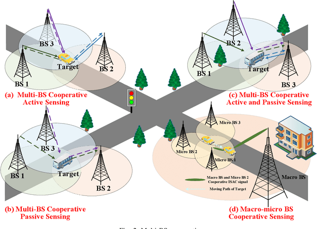
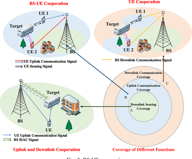
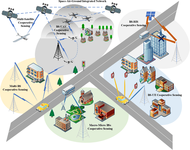
With the mobile communication system evolving into 6th-generation (6G), the Internet of Everything (IoE) is becoming reality, which connects human, big data and intelligent machines to support the intelligent decision making, reconfiguring the traditional industries and human life. The applications of IoE require not only pure communication capability, but also high-accuracy and large-scale sensing capability. With the emerging integrated sensing and communication (ISAC) technique, exploiting the mobile communication system with multi-domain resources, multiple network elements, and large-scale infrastructures to realize cooperative sensing is a crucial approach to satisfy the requirements of high-accuracy and large-scale sensing in IoE. In this article, the deep cooperation in ISAC system including three perspectives is investigated. In the microscopic perspective, namely, within a single node, the cooperation at the resource-level is performed to improve sensing accuracy by fusing the sensing information carried in the time-frequency-space-code multi-domain resources. In the mesoscopic perspective, the sensing accuracy could be improved through the cooperation of multiple nodes including Base Station (BS), User Equipment (UE), and Reconfigurable Intelligence Surface (RIS), etc. In the macroscopic perspective, the massive number of infrastructures from the same operator or different operators could perform cooperative sensing to extend the sensing coverage and improve the sensing continuity. This article may provide a deep and comprehensive view on the cooperative sensing in ISAC system to enhance the performance of sensing, supporting the applications of IoE.
Integrated Sensing and Communication Driven Digital Twin for Intelligent Machine Network
Feb 08, 2024Intelligent machines (IMs), including industrial machines, unmanned aerial vehicles (UAVs), and unmanned vehicles, etc., could perform effective cooperation in complex environment when they form IM network. The efficient environment sensing and communication are crucial for IM network, enabling the real-time and stable control of IMs. With the emergence of integrated sensing and communication (ISAC) technology, IM network is empowered with ubiquitous sensing capabilities, which is helpful in improving the efficiency of communication and sensing with the mutual benefit of them. However, the massive amount of sensing information brings challenges for the processing, storage and application of sensing information. In this article, ISAC driven digital twin (DT) is proposed for IM network, and the architecture and enabling technologies are revealed. ISAC driven DT structurally stores the sensing information, which is further applied to optimize communication, networking and control schemes of IMs, promoting the widespread applications of IMs.
Radio Map-Based Spectrum Sharing for Joint Communication and Sensing
Jan 04, 2024The sixth-generation (6G) network is expected to provide both communication and sensing (C&S) services. However, spectrum scarcity poses a major challenge to the harmonious coexistence of C&S systems. Without effective cooperation, the interference resulting from spectrum sharing impairs the performance of both systems. This paper addresses C&S interference within a distributed network. Different from traditional schemes that require pilot-based high-frequency interactions between C&S systems, we introduce a third party named the radio map to provide the large-scale channel state information (CSI). With large-scale CSI, we optimize the transmit power of C&S systems to maximize the signal-to-interference-plus-noise ratio (SINR) for the radar detection, while meeting the ergodic rate requirement of the interfered user. Given the non-convexity of both the objective and constraint, we employ the techniques of auxiliary-function-based scaling and fraction programming for simplification. Subsequently, we propose an iterative algorithm to solve this problem. Simulation results collaborate our idea that the extrinsic information, i.e., positions and surroundings, is effective to decouple C&S interference.
Attribute Simulation for Item Embedding Enhancement in Multi-interest Recommendation
Nov 29, 2023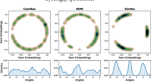
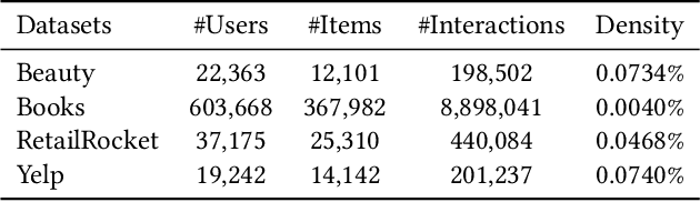
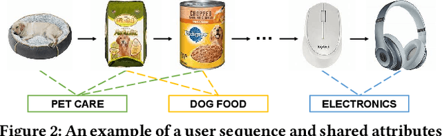

Although multi-interest recommenders have achieved significant progress in the matching stage, our research reveals that existing models tend to exhibit an under-clustered item embedding space, which leads to a low discernibility between items and hampers item retrieval. This highlights the necessity for item embedding enhancement. However, item attributes, which serve as effective and straightforward side information for enhancement, are either unavailable or incomplete in many public datasets due to the labor-intensive nature of manual annotation tasks. This dilemma raises two meaningful questions: 1. Can we bypass manual annotation and directly simulate complete attribute information from the interaction data? And 2. If feasible, how to simulate attributes with high accuracy and low complexity in the matching stage? In this paper, we first establish an inspiring theoretical feasibility that the item-attribute correlation matrix can be approximated through elementary transformations on the item co-occurrence matrix. Then based on formula derivation, we propose a simple yet effective module, SimEmb (Item Embedding Enhancement via Simulated Attribute), in the multi-interest recommendation of the matching stage to implement our findings. By simulating attributes with the co-occurrence matrix, SimEmb discards the item ID-based embedding and employs the attribute-weighted summation for item embedding enhancement. Comprehensive experiments on four benchmark datasets demonstrate that our approach notably enhances the clustering of item embedding and significantly outperforms SOTA models with an average improvement of 25.59% on Recall@20.
Spectrum Sharing between UAV-based Wireless Mesh Networks and Ground Networks
Nov 25, 2023The unmanned aerial vehicle (UAV)-based wireless mesh networks can economically provide wireless services for the areas with disasters. However, the capacity of air-to-air communications is limited due to the multi-hop transmissions. In this paper, the spectrum sharing between UAV-based wireless mesh networks and ground networks is studied to improve the capacity of the UAV networks. Considering the distribution of UAVs as a three-dimensional (3D) homogeneous Poisson point process (PPP) within a vertical range, the stochastic geometry is applied to analyze the impact of the height of UAVs, the transmit power of UAVs, the density of UAVs and the vertical range, etc., on the coverage probability of ground network user and UAV network user, respectively. The optimal height of UAVs is numerically achieved in maximizing the capacity of UAV networks with the constraint of the coverage probability of ground network user. This paper provides a basic guideline for the deployment of UAV-based wireless mesh networks.
Capacity and Delay of Unmanned Aerial Vehicle Networks with Mobility
Nov 25, 2023Unmanned aerial vehicles (UAVs) are widely exploited in environment monitoring, search-and-rescue, etc. However, the mobility and short flight duration of UAVs bring challenges for UAV networking. In this paper, we study the UAV networks with n UAVs acting as aerial sensors. UAVs generally have short flight duration and need to frequently get energy replenishment from the control station. Hence the returning UAVs bring the data of the UAVs along the returning paths to the control station with a store-carry-and-forward (SCF) mode. A critical range for the distance between the UAV and the control station is discovered. Within the critical range, the per-node capacity of the SCF mode is O(n/log n) times higher than that of the multi-hop mode. However, the per-node capacity of the SCF mode outside the critical range decreases with the distance between the UAV and the control station. To eliminate the critical range, a mobility control scheme is proposed such that the capacity scaling laws of the SCF mode are the same for all UAVs, which improves the capacity performance of UAV networks. Moreover, the delay of the SCF mode is derived. The impact of the size of the entire region, the velocity of UAVs, the number of UAVs and the flight duration of UAVs on the delay of SCF mode is analyzed. This paper reveals that the mobility and short flight duration of UAVs have beneficial effects on the performance of UAV networks, which may motivate the study of SCF schemes for UAV networks.